| Right-click this to download the KML file |
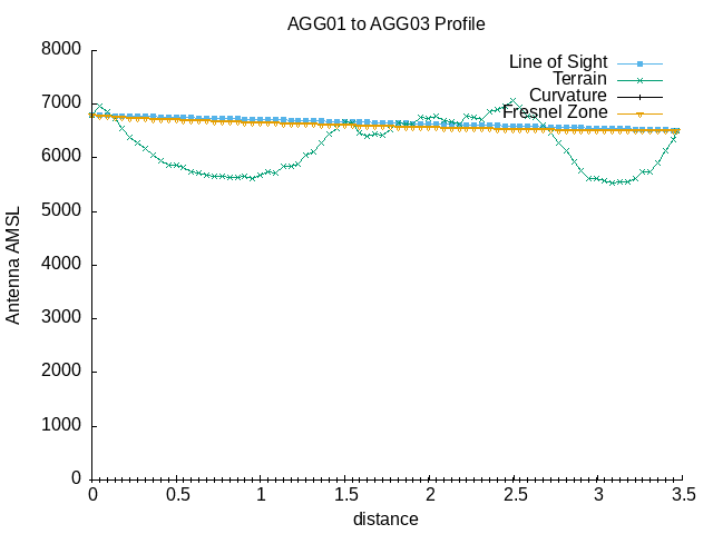 |
| --==[ Path Profile Analysis ]==-- |
| Transmitter site: Tx |
| Site location: -41.2047, -71.5390 |
| Ground elevation: 6781.50 feet AMSL |
| Antenna height: 16.00 feet AGL / 6797.50 feet AMSL |
| Distance to Rx: 3.47 miles |
| Azimuth to Rx: 63.42 degrees grid |
| Downtilt angle to Rx: -0.9087 degrees |
| Receiver site: Rx |
| Site location: -41.1823, -71.4794 |
| Ground elevation: 6499.34 feet AMSL |
| Antenna height: 16.00 feet AGL / 6515.34 feet AMSL |
| Distance to Tx: 3.47 miles |
| Azimuth to Tx: 243.38 degrees grid |
| Downtilt angle to Tx: +0.8586 degrees |
| Propagation model: Line of sight |
| Model sub-type: Rural / Optimistic |
| Earth's Dielectric Constant: 15.000 |
| Earth's Conductivity: 0.005 Siemens/meter |
| Atmospheric Bending Constant (N-units): 301.000 ppm |
| Frequency: 915.000 MHz |
| Radio Climate: 5 (Continental Temperate) |
| Polarisation: 1 (Vertical) |
| Fraction of Situations: 50.0% |
| Fraction of Time: 50.0% |
| Summary for the link between Tx and Rx: |
| Free space path loss: 106.62 dB |
| Computed path loss: 195.60 dB |
| Attenuation due to terrain shielding: 88.98 dB |
| Between Rx and Tx, obstructions were detected at: |
| 41.1874 S, 71.4930 W, 0.79 miles, 6610.89 feet AMSL |
| 41.1877 S, 71.4938 W, 0.84 miles, 6751.97 feet AMSL |
| 41.1880 S, 71.4946 W, 0.88 miles, 6781.50 feet AMSL |
| 41.1883 S, 71.4954 W, 0.93 miles, 6935.70 feet AMSL |
| 41.1886 S, 71.4961 W, 0.97 miles, 7066.93 feet AMSL |
| 41.2042 S, 71.5375 W, 3.37 miles, 6860.24 feet AMSL |
| 41.2045 S, 71.5383 W, 3.42 miles, 6958.66 feet AMSL |
| Antenna at Rx must be raised to at least 12618.00 feet AGL |
| to clear all obstructions detected. |
| Antenna at Rx must be raised to at least 13836.00 feet AGL |
| to clear the first Fresnel zone. |
| Antenna at Rx must be raised to at least 13349.00 feet AGL |
| to clear 600f the first Fresnel zone. |