| Right-click this to download the KML file |
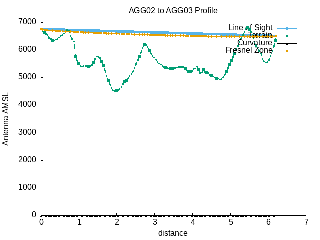 |
| --==[ Path Profile Analysis ]==-- |
| Transmitter site: Tx |
| Site location: -41.1823, -71.5988 |
| Ground elevation: 6745.41 feet AMSL |
| Antenna height: 16.00 feet AGL / 6761.41 feet AMSL |
| Distance to Rx: 6.21 miles |
| Azimuth to Rx: 90.04 degrees grid |
| Downtilt angle to Rx: -0.4751 degrees |
| Receiver site: Rx |
| Site location: -41.1823, -71.4794 |
| Ground elevation: 6499.34 feet AMSL |
| Antenna height: 16.00 feet AGL / 6515.34 feet AMSL |
| Distance to Tx: 6.21 miles |
| Azimuth to Tx: 269.96 degrees grid |
| Downtilt angle to Tx: +0.3853 degrees |
| Propagation model: Line of sight |
| Model sub-type: Rural / Optimistic |
| Earth's Dielectric Constant: 15.000 |
| Earth's Conductivity: 0.005 Siemens/meter |
| Atmospheric Bending Constant (N-units): 301.000 ppm |
| Frequency: 915.000 MHz |
| Radio Climate: 5 (Continental Temperate) |
| Polarisation: 1 (Vertical) |
| Fraction of Situations: 50.0% |
| Fraction of Time: 50.0% |
| Summary for the link between Tx and Rx: |
| Free space path loss: 111.69 dB |
| Computed path loss: 190.31 dB |
| Attenuation due to terrain shielding: 78.62 dB |
| Between Rx and Tx, obstructions were detected at: |
| 41.1823 S, 71.4913 W, 0.62 miles, 6538.71 feet AMSL |
| 41.1823 S, 71.4921 W, 0.66 miles, 6660.11 feet AMSL |
| 41.1823 S, 71.4930 W, 0.70 miles, 6738.85 feet AMSL |
| 41.1823 S, 71.4938 W, 0.75 miles, 6811.02 feet AMSL |
| Antenna at Rx must be raised to at least 322.00 feet AGL |
| to clear all obstructions detected. |
| Antenna at Rx must be raised to at least 525.00 feet AGL |
| to clear the first Fresnel zone. |
| Antenna at Rx must be raised to at least 364.00 feet AGL |
| to clear 600f the first Fresnel zone. |