| Right-click this to download the KML file |
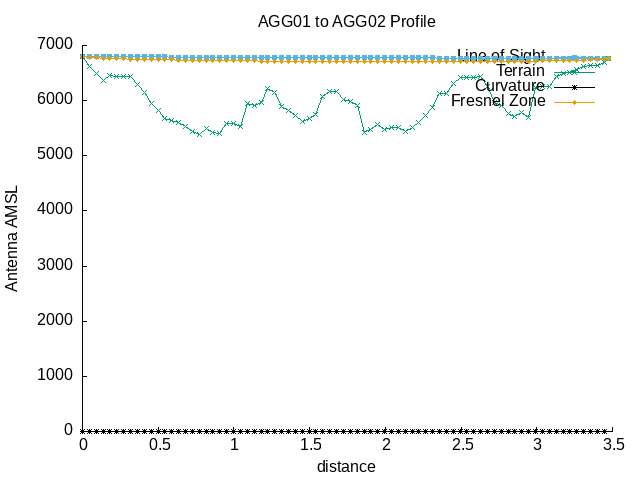 |
| --==[ Path Profile Analysis ]==-- |
| Transmitter site: Tx |
| Site location: -41.2047, -71.5390 |
| Ground elevation: 6781.50 feet AMSL |
| Antenna height: 16.00 feet AGL / 6797.50 feet AMSL |
| Distance to Rx: 3.47 miles |
| Azimuth to Rx: 296.51 degrees grid |
| Downtilt angle to Rx: -0.1379 degrees |
| Receiver site: Rx |
| Site location: -41.1823, -71.5988 |
| Ground elevation: 6745.41 feet AMSL |
| Antenna height: 16.00 feet AGL / 6761.41 feet AMSL |
| Distance to Tx: 3.47 miles |
| Azimuth to Tx: 116.55 degrees grid |
| Downtilt angle to Tx: +0.0876 degrees |
| Propagation model: Line of sight |
| Model sub-type: Rural / Optimistic |
| Earth's Dielectric Constant: 15.000 |
| Earth's Conductivity: 0.005 Siemens/meter |
| Atmospheric Bending Constant (N-units): 301.000 ppm |
| Frequency: 915.000 MHz |
| Radio Climate: 5 (Continental Temperate) |
| Polarisation: 1 (Vertical) |
| Fraction of Situations: 50.0% |
| Fraction of Time: 50.0% |
| Summary for the link between Tx and Rx: |
| Free space path loss: 106.64 dB |
| Computed path loss: 106.44 dB |
| Attenuation due to terrain shielding: -0.20 dB |
| No obstructions to LOS path due to terrain were detected |
| The first Fresnel zone is clear. |
| 600f the first Fresnel zone is clear. |