| Right-click this to download the KML file |
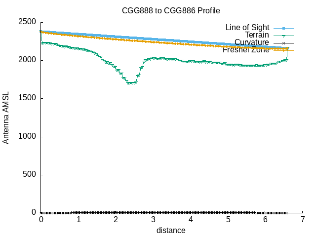 |
| --==[ Path Profile Analysis ]==-- |
| Transmitter site: Tx |
| Site location: 53.8320, -110.7848 |
| Ground elevation: 2230.97 feet AMSL |
| Antenna height: 150.00 feet AGL / 2380.97 feet AMSL |
| Distance to Rx: 6.60 miles |
| Azimuth to Rx: 318.08 degrees grid |
| Downtilt angle to Rx: -0.4090 degrees |
| Receiver site: Rx |
| Site location: 53.9030, -110.8932 |
| Ground elevation: 2011.15 feet AMSL |
| Antenna height: 150.00 feet AGL / 2161.15 feet AMSL |
| Distance to Tx: 6.60 miles |
| Azimuth to Tx: 137.99 degrees grid |
| Downtilt angle to Tx: +0.3135 degrees |
| Propagation model: Line of sight |
| Model sub-type: Rural / Optimistic |
| Earth's Dielectric Constant: 15.000 |
| Earth's Conductivity: 0.005 Siemens/meter |
| Atmospheric Bending Constant (N-units): 301.000 ppm |
| Frequency: 5800.000 MHz |
| Radio Climate: 5 (Continental Temperate) |
| Polarisation: 1 (Vertical) |
| Fraction of Situations: 50.0% |
| Fraction of Time: 50.0% |
| Summary for the link between Tx and Rx: |
| Free space path loss: 128.26 dB |
| Computed path loss: 128.15 dB |
| Attenuation due to terrain shielding: -0.11 dB |
| No obstructions to LOS path due to terrain were detected |
| The first Fresnel zone is clear. |
| 600f the first Fresnel zone is clear. |