| Right-click this to download the KML file |
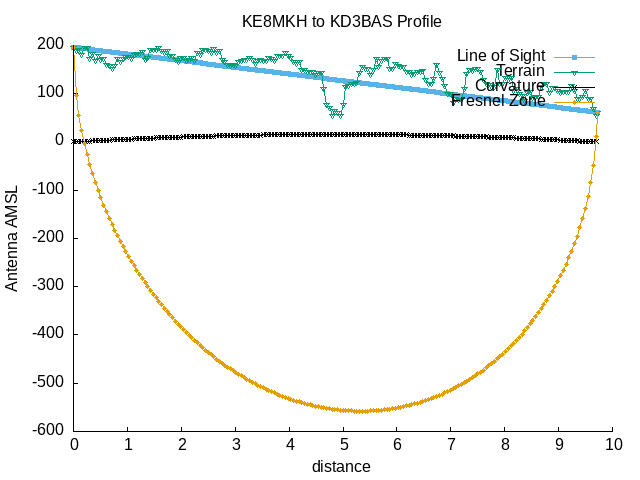 |
| --==[ Path Profile Analysis ]==-- |
| Transmitter site: Tx |
| Site location: 38.5474, -77.0805 |
| Ground elevation: 190.29 feet AMSL |
| Antenna height: 6.00 feet AGL / 196.29 feet AMSL |
| Distance to Rx: 9.71 miles |
| Azimuth to Rx: 221.05 degrees grid |
| Downtilt angle to Rx: -0.2206 degrees |
| Receiver site: Rx |
| Site location: 38.4413, -77.1983 |
| Ground elevation: 55.77 feet AMSL |
| Antenna height: 6.00 feet AGL / 61.77 feet AMSL |
| Distance to Tx: 9.71 miles |
| Azimuth to Tx: 40.97 degrees grid |
| Downtilt angle to Tx: +0.0800 degrees |
| Propagation model: Line of sight |
| Model sub-type: Rural / Optimistic |
| Earth's Dielectric Constant: 15.000 |
| Earth's Conductivity: 0.005 Siemens/meter |
| Atmospheric Bending Constant (N-units): 301.000 ppm |
| Frequency: 27.000 MHz |
| Radio Climate: 5 (Continental Temperate) |
| Polarisation: 1 (Vertical) |
| Fraction of Situations: 50.0% |
| Fraction of Time: 50.0% |
| Summary for the link between Tx and Rx: |
| Free space path loss: 84.97 dB |
| Computed path loss: 135.34 dB |
| Attenuation due to terrain shielding: 50.37 dB |
| Between Rx and Tx, obstructions were detected at: |
| 38.4420 N, 77.1975 W, 0.06 miles, 68.90 feet AMSL |
| 38.4426 N, 77.1969 W, 0.12 miles, 88.58 feet AMSL |
| 38.4437 N, 77.1957 W, 0.22 miles, 104.99 feet AMSL |
| 38.4465 N, 77.1926 W, 0.47 miles, 114.83 feet AMSL |
| 38.4588 N, 77.1790 W, 1.60 miles, 124.67 feet AMSL |
| 38.4616 N, 77.1759 W, 1.85 miles, 141.08 feet AMSL |
| 38.4738 N, 77.1623 W, 2.97 miles, 147.64 feet AMSL |
| 38.4839 N, 77.1511 W, 3.89 miles, 157.48 feet AMSL |
| 38.5045 N, 77.1282 W, 5.78 miles, 170.60 feet AMSL |
| 38.5179 N, 77.1133 W, 7.01 miles, 177.17 feet AMSL |
| 38.5190 N, 77.1121 W, 7.11 miles, 180.45 feet AMSL |
| 38.5301 N, 77.0997 W, 8.13 miles, 187.01 feet AMSL |
| Antenna at Rx must be raised to at least 137.00 feet AGL |
| to clear all obstructions detected. |
| Antenna at Rx must be raised to at least 17865.00 feet AGL |
| to clear the first Fresnel zone. |
| Antenna at Rx must be raised to at least 10346.00 feet AGL |
| to clear 600f the first Fresnel zone. |